Now since the last NHC forecast point with the 60mph forecast, is inland a bit, this means the max intensity should probably be 70mph or 75mph right before landfall.
This is consistent with a Category 1 landfall.
I think NHC will need to issue Hurricane Watches at some point for PTC7.
532
WTNT62 KNHC 031202
TCUAT2
Tropical Storm Gordon Tropical Cyclone Update
NWS National Hurricane Center Miami FL AL072018
805 AM EDT Mon Sep 03 2018
…TROPICAL STORM GORDON FORMS NEAR THE UPPER FLORIDA KEYS…
…TROPICAL STORM WARNINGS ISSUED FOR PORTIONS OF SOUTH FLORIDA AND
THE KEYS…
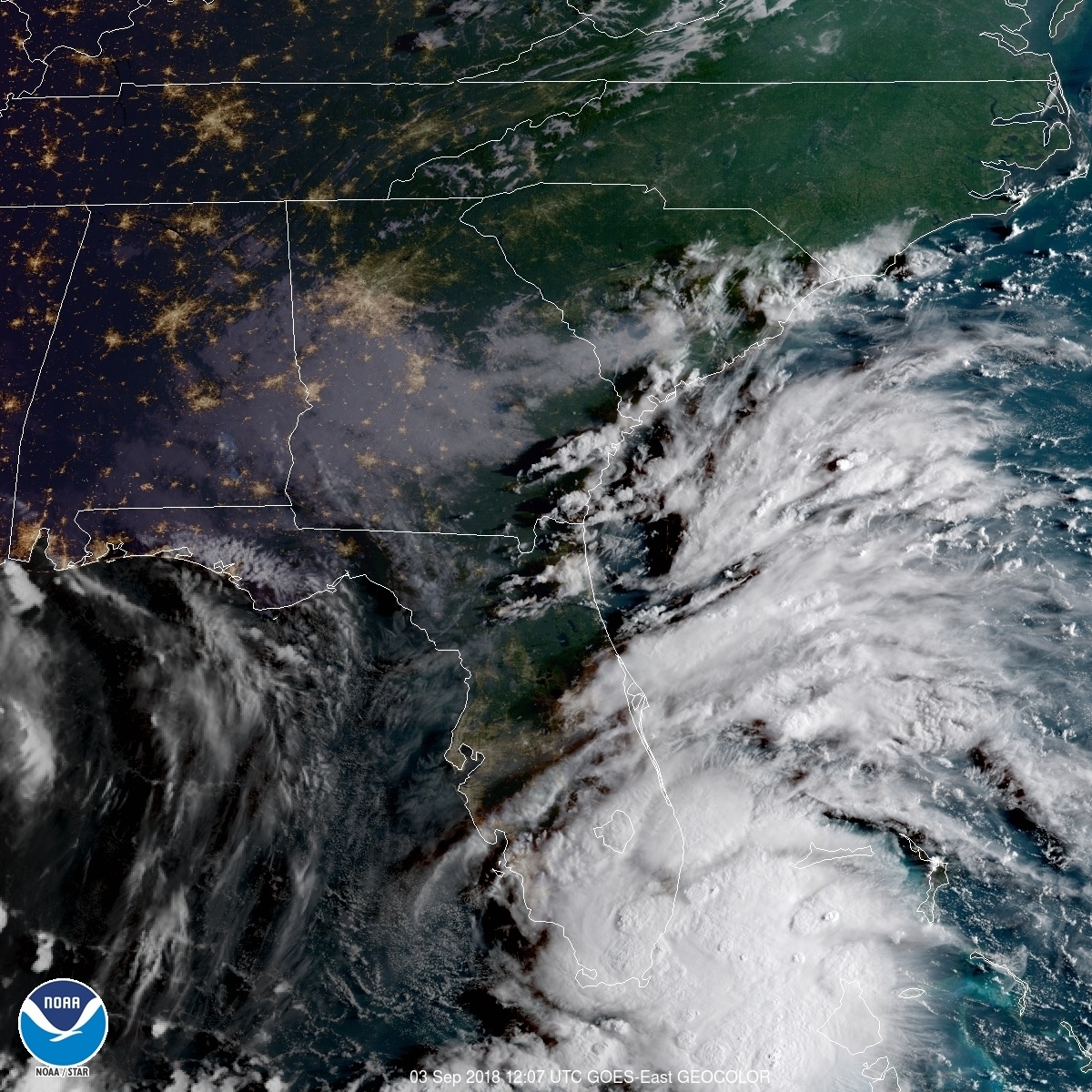
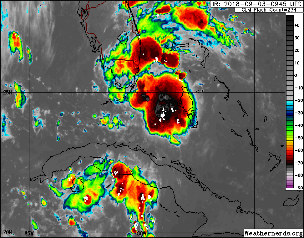
Surface observations from the Florida Keys and radar data indicate
that Potential Tropical Cyclone Seven has become Tropical Storm
Gordon, with maximum sustained winds of around 45 mph (75 km/h). A
Tropical Storm Warning will be issued shortly for portions of the
Florida Keys and the southern Florida peninsula in a forthcoming
special advisory to be issued by 900 AM EDT (1300 UTC).
SUMMARY OF 805 AM EDT…1205 UTC…INFORMATION
—————————————————
LOCATION…25.1N 80.6W
ABOUT 10 MI…15 KM W OF KEY LARGO FLORIDA
ABOUT 30 MI…50 KM E OF CAPE SABLE FLORIDA
MAXIMUM SUSTAINED WINDS…45 MPH…75 KM/H
PRESENT MOVEMENT…WNW OR 300 DEGREES AT 16 MPH…26 KM/H
MINIMUM CENTRAL PRESSURE…1009 MB…29.79 INCHES
$$
Forecaster Brennan/Stewart
@NHC_Atlantic
Tropical Storm #Gordon has formed near the Upper Florida Keys, with maximum winds of 45 mph. Tropical Storm Warnings are coming for portions of south Florida and the Keys in a Special Advisory to be issued by 9 am EDT (1300 UTC). More:
@hurrtrackerapp
Seguir Seguir @hurrtrackerapp
Mais
BREAKING: Tropical Storm #Gordon has formed near the Upper Florida Keys, with winds up to 45 mph. Tropical Storm Warnings are coming for portions of South Florida and the Keys in a Special Advisory to be issued by 9am EDT.
BREAKING: Tropical Storm #Gordon has formed near the Upper Florida Keys, with winds up to 45 mph. Tropical Storm Warnings are coming for portions of South Florida and the Keys in a Special Advisory to be issued by 9am EDT. pic.twitter.com/2HUiTNGyNA
— Hurricane Tracker App (@hurrtrackerapp) September 3, 2018
674
WTNT32 KNHC 031227
TCPAT2
BULLETIN
Tropical Storm Gordon Special Advisory Number 4
NWS National Hurricane Center Miami FL AL072018
830 AM EDT Mon Sep 03 2018
…TROPICAL STORM GORDON FORMS OVER THE UPPER FLORIDA KEYS…
…TROPICAL STORM WARNINGS ISSUED FOR PORTIONS OF SOUTH FLORIDA
AND THE FLORIDA KEYS WITH HEAVY RAINS LIKELY…
SUMMARY OF 830 AM EDT…1230 UTC…INFORMATION
———————————————-
LOCATION…25.1N 80.7W
ABOUT 20 MI…30 KM W OF KEY LARGO FLORIDA
ABOUT 85 MI…135 KM SE OF MARCO ISLAND FLORIDA
MAXIMUM SUSTAINED WINDS…45 MPH…75 KM/H
PRESENT MOVEMENT…WNW OR 300 DEGREES AT 17 MPH…28 KM/H
MINIMUM CENTRAL PRESSURE…1009 MB…29.80 INCHES
Eric Webb
@webberweather
Frictional veering with the flat, low-lying terrain of south Florida likely helped #PTC7 attain earth relative westerlies & become TS #Gordon in an otherwise somewhat unfavorable large-scale regime characterized by fast east-southeasterly flow aloft.
@hurrtrackerapp
1 minHá 1 minuto
Mais
A Tropical Storm Warning has been issued for portions of South Florida from Golden Beach to Bonita Beach, and for the Florida Keys from Craig Key to Ocean Reef, including Florida Bay. #Gordon
The fact Gordon has formed just now when most didn’t expect an actual TS before entering the GOM puts the intensity forecast in more uncertain territory in my opinion. The only thing really hindering it will be fast movement, shear should be moving out of the way for the system.
678
WTNT42 KNHC 031236
TCDAT2
Tropical Storm Gordon Special Discussion Number 4
NWS National Hurricane Center Miami FL AL072018
830 AM EDT Mon Sep 03 2018
Surface observations from the Florida Keys and southeast Florida,
along with Doppler velocity data from the Miami radar, indicate
that the disturbance has developed a closed surface circulation and
a well-defined center. Recent observations from a Weatherflow site
at Carys Fort Reef and radar data support increasing the maximum
winds to at least 40 kt. As a result of these data, the system has
been upgraded to Tropical Storm Gordon, the seventh named system of
the 2018 Atlantic hurricane season. An Air Force Reserve Unit
reconnaissance aircraft is enroute to investigate Gordon.
The initial motion estimate is 300/15 kt and the previous forecast
track remains unchanged. The intensity forecast was adjusted upward
in the first 24 to 36 hours to account for the initial increase in
intensity. Some additional adjustments may be required after the
reconnaissance aircraft completes its mission and provides more
detailed information on the stricture and intensity of Gordon.
Key Messages:
1. Gordon will bring heavy rainfall and tropical storm conditions to
portions of South Florida and the Florida Keys today and a Tropical
Storm Warning is in effect for these areas.
2. A Tropical Storm Warning is in effect for portions of the
central Gulf Coast, and tropical storm conditions are expected in
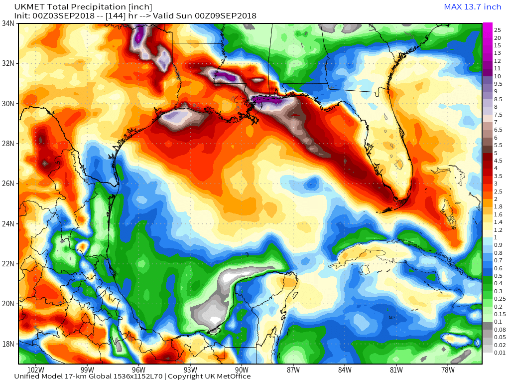
those areas beginning late Tuesday. Heavy rainfall from Gordon will
affect portions of the central Gulf Coast over the next few days,
including areas that have already received heavy rainfall from a
different weather system. Interests in these areas should monitor
products from their local National Weather Service office.
FORECAST POSITIONS AND MAX WINDS
INIT 03/1230Z 25.1N 80.7W 40 KT 45 MPH
12H 03/1800Z 25.7N 82.1W 45 KT 50 MPH
24H 04/0600Z 27.2N 84.8W 50 KT 60 MPH
36H 04/1800Z 28.8N 87.4W 50 KT 60 MPH
48H 05/0600Z 30.4N 89.7W 50 KT 60 MPH
72H 06/0600Z 33.0N 92.7W 30 KT 35 MPH…INLAND
96H 07/0600Z 34.0N 95.0W 25 KT 30 MPH…INLAND
120H 08/0600Z 35.5N 96.0W 20 KT 25 MPH…POST-TROP/REMNT LOW
$$
Forecaster Stewart
@hurrtrackerapp
Seguir Seguir @hurrtrackerapp
Mais
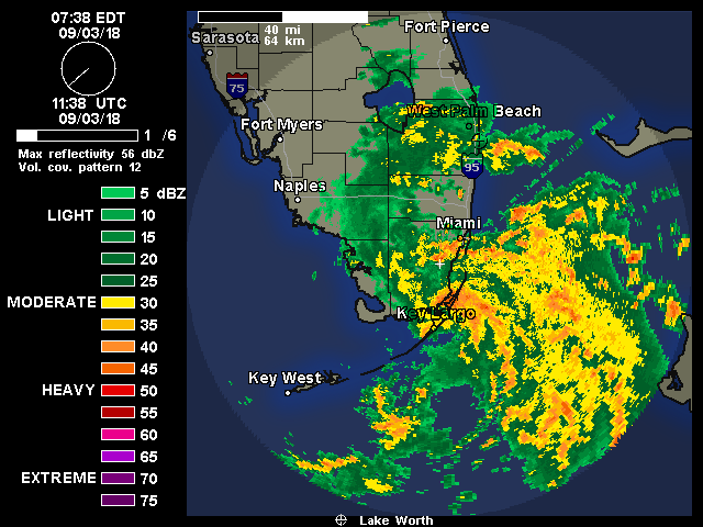
Watch as #Gordon organizes from a tropical wave into a tropical storm since Sunday on this radar loop, courtesy of @BMcNoldy.
Watch as #Gordon organizes from a tropical wave into a tropical storm since Sunday on this radar loop, courtesy of @BMcNoldy. pic.twitter.com/E32LK55ngb
— Hurricane Tracker App (@hurrtrackerapp) September 3, 2018
@hurrtrackerapp
5 minHá 5 minutos
Mais
A general 2-4 inches is forecast for South Florida today but localized areas may receive as much as 8 inches of rainfall. Flash flooding will be possible. #Gordon
@hurrtrackerapp
2 minHá 2 minutos
Mais
Not too hard to tell that we’re nearing the typical peak of Atlantic hurricane season activity. We have Tropical Storms #Florence and #Gordon currently active as well as an area to watch with a 30% chance of development.
Russ Adams
@patpend
I keep repeating “this is the year of rapid near shore development”. Take ALL tropical storms seriously because they could become a Major hurricane with only 48hrs notice.
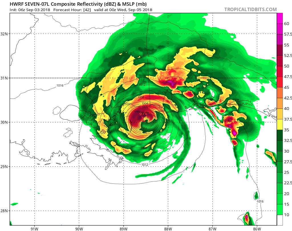
974Mb landfall…
@hurrtrackerapp
4 minHá 4 minutos
Mais
A Storm Surge Watch is in effect from the Mississippi-Alabama border westward to the Mouth of the Mississippi River. 2-4 feet of surge is currently forecast for these areas. #Gordon
up ahead…———————-
STORM SURGE: The combination of a dangerous storm surge and the tide will cause normally dry areas near the coast to be flooded by rising waters moving inland from the shoreline. The water could reach the following heights above ground somewhere in the indicated areas if the peak surge occurs at the time of high tide…
Destin Florida to the Mississippi-Alabama border…1 to 2 ft.
Mississippi-Alabama border to the Mouth of Mississippi River…2 to 4 ft
Mouth of the Mississippi River to the Louisiana-Texas border…1 to 2 ft
The deepest water will occur along the immediate coast near and to the east of the landfall location, where the surge will be accompanied by large waves. Surge-related flooding depends on the relative timing of the surge and the tidal cycle, and can vary greatly over short distances.
For information specific to your area, please see products issued by your local National Weather Service
forecast office.
RAINFALL: Gordon is expected to produce total rain accumulations of 2 to 4 inches over the central and northwestern Bahamas, the Florida Keys, and South Florida through early Tuesday. Isolated maximum
amounts of 8 inches are possible over the southern Florida peninsula.
Gordon is expected to produce total rain accumulations of 4 to 6 inches over southern Alabama, southern Mississippi and Louisiana, with isolated maximum amounts of 8 inches through early Thursday.
These rainfall amounts may cause flash flooding.
FORECAST POSITIONS AND MAX WINDS
INIT 03/1500Z 25.3N 81.3W 40 KT 45 MPH
12H 04/0000Z 26.5N 83.4W 45 KT 50 MPH
24H 04/1200Z 28.1N 86.0W 50 KT 60 MPH
36H 05/0000Z 29.9N 88.4W 60 KT 70 MPH
48H 05/1200Z 31.3N 90.3W 40 KT 45 MPH…INLAND
72H 06/1200Z 33.9N 93.2W 25 KT 30 MPH…INLAND
96H 07/1200Z 34.8N 94.9W 20 KT 25 MPH…INLAND
120H 08/1200Z 37.6N 95.1W 20 KT 25 MPH…POST-TROP/REMNT LOW
$$
Forecaster Stewart
h/t Luisport